Wayfinding PlannerMessage schedules and sign location plans in minutes, not days
Key features
Wayfinding system model
A single source of truth for your wayfinding strategy, connecting user routes, sign locations, and destination endpoints into one consistent system.
Effortless iterations
Move signs, change routes, group destinations, rename messages, and adjust progressive disclosure settings as your strategy evolves. WFP keeps everything updated instantly.
One-click export
Export project deliverables instantly in one complete package: sign location plans as PDF, and the Message Schedule and Sign Bill of Quantities as CSV.
Analysis and inspection
See which signs point to each destination, which messages appear on each sign, and why. Review routes, inspect destination groups, and fine-tune sign contents in context.
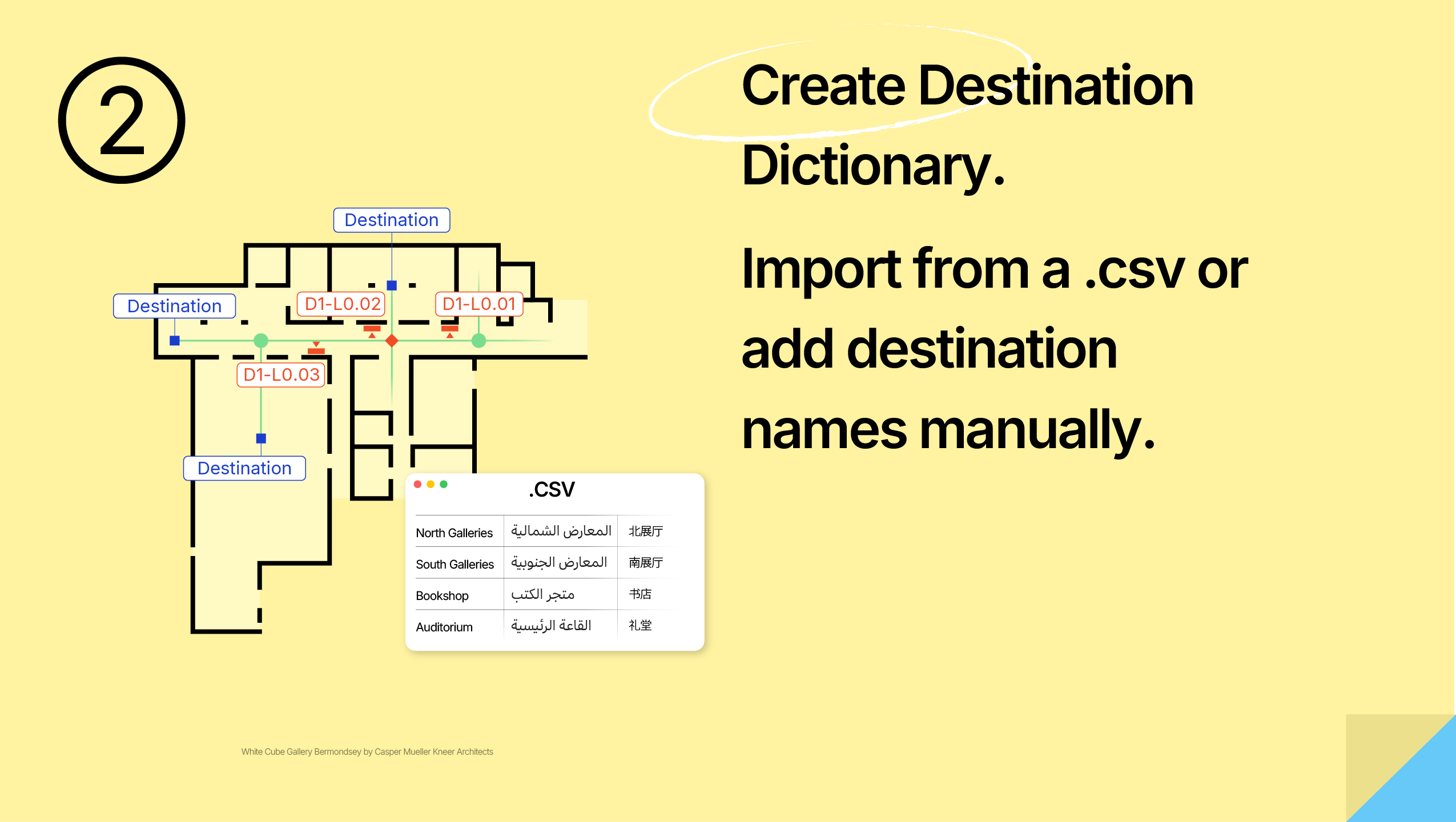
Destination Dictionary
Manage destinations in one place. Bind them to target points with drag and drop, edit them manually or via CSV, and re-import updates at any time. Your message schedule updates automatically as destination data changes.
Flexible sign types
Choose from built-in single-sided, double-sided, and fingerpost sign types, or create your own fully custom multi-face sign configuration.
One-step level cloning
Clone similar levels. Offset numeric destination names as part of the same operation.

Minutes, not hours
Focus on product design and user experience - let the software handle propagation of your changes.
Available on macOS, Windows, and the Web
Use the native macOS or Windows app, or open the web version with no download required.
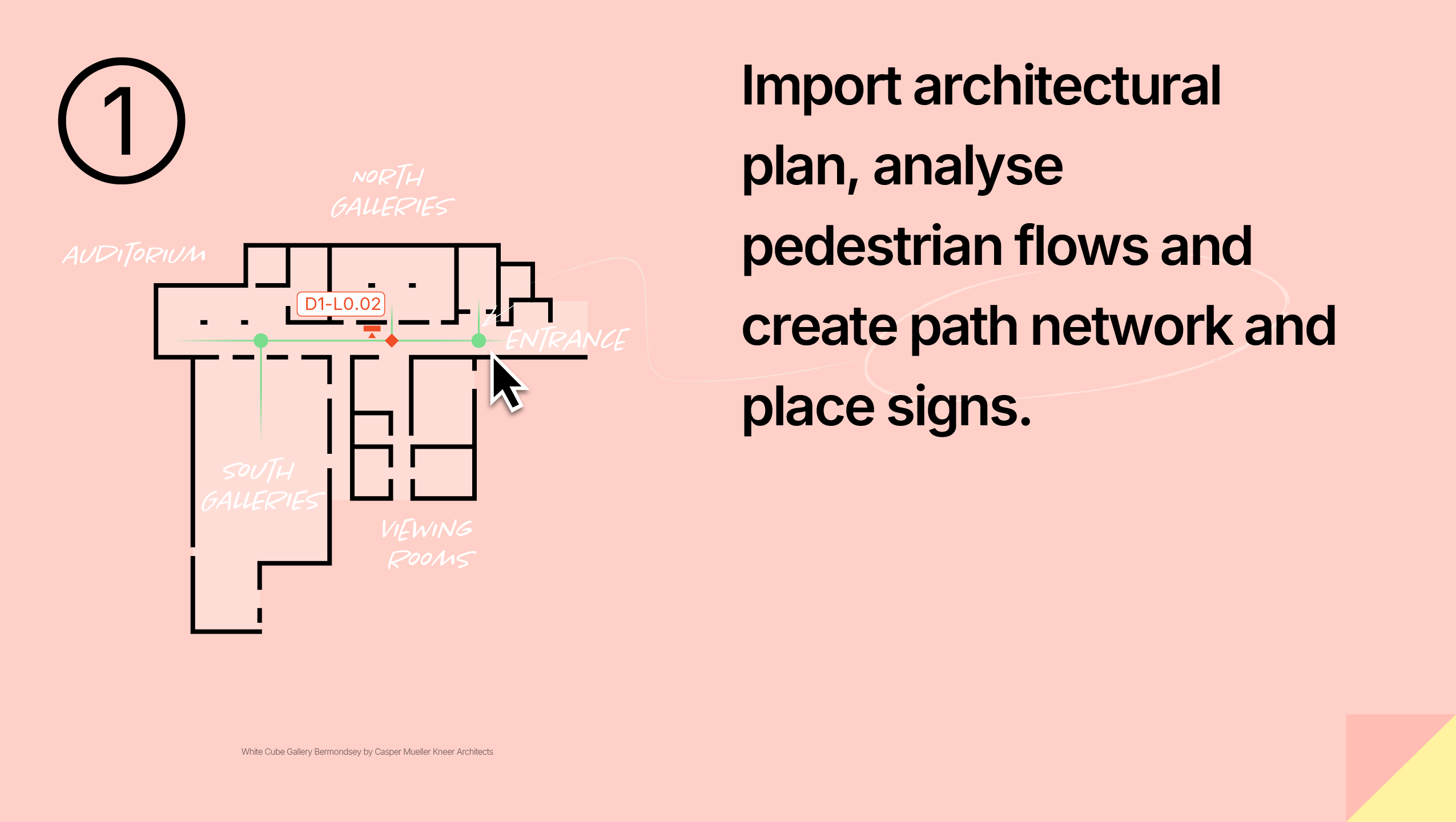
Typical workflow
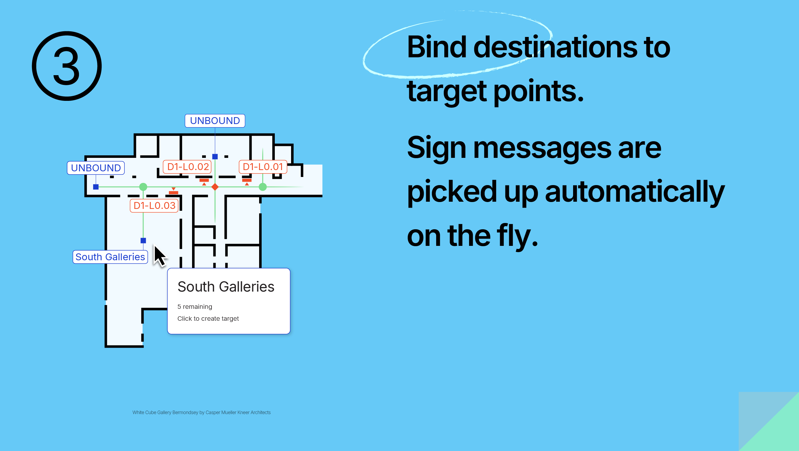
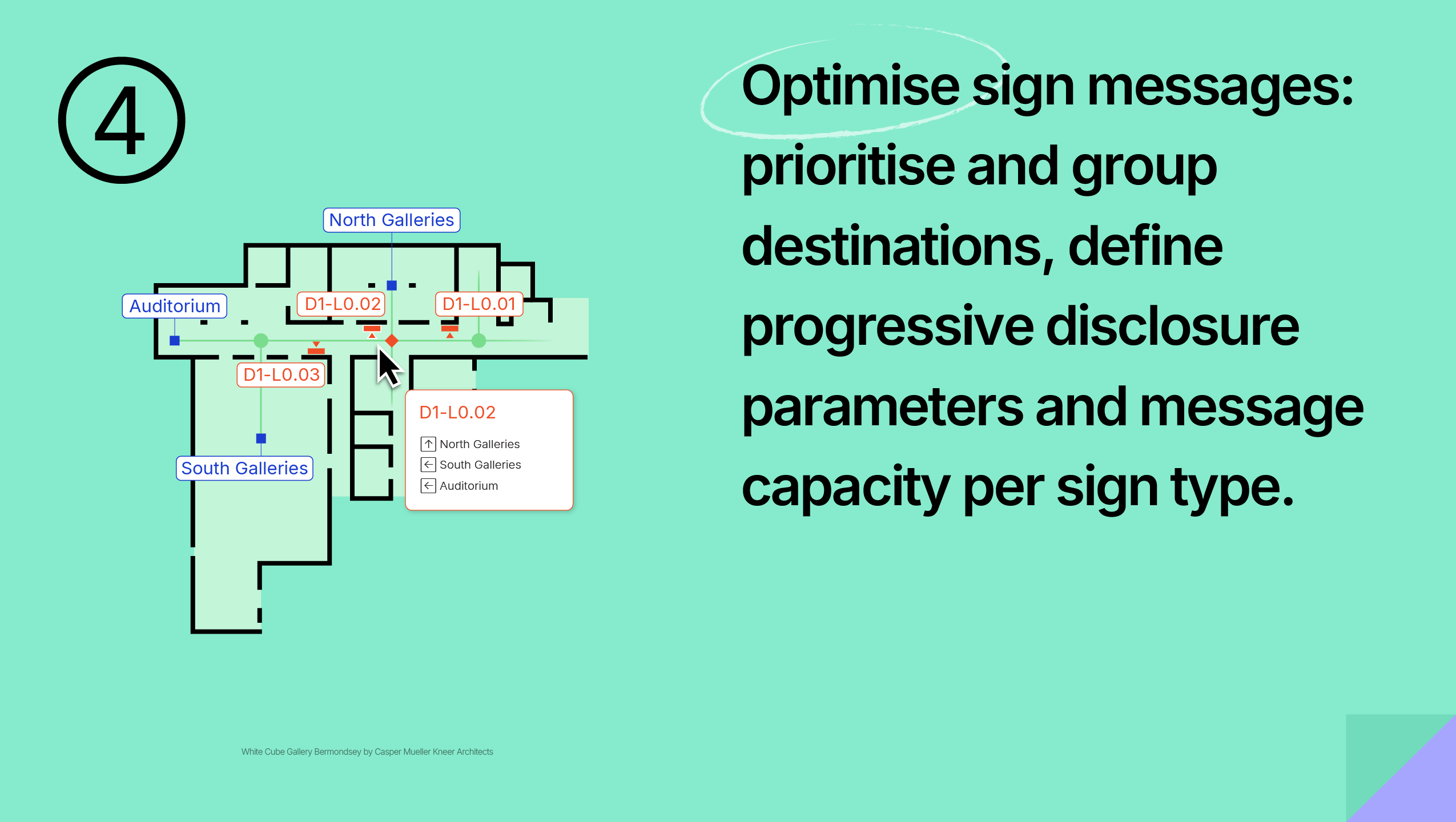
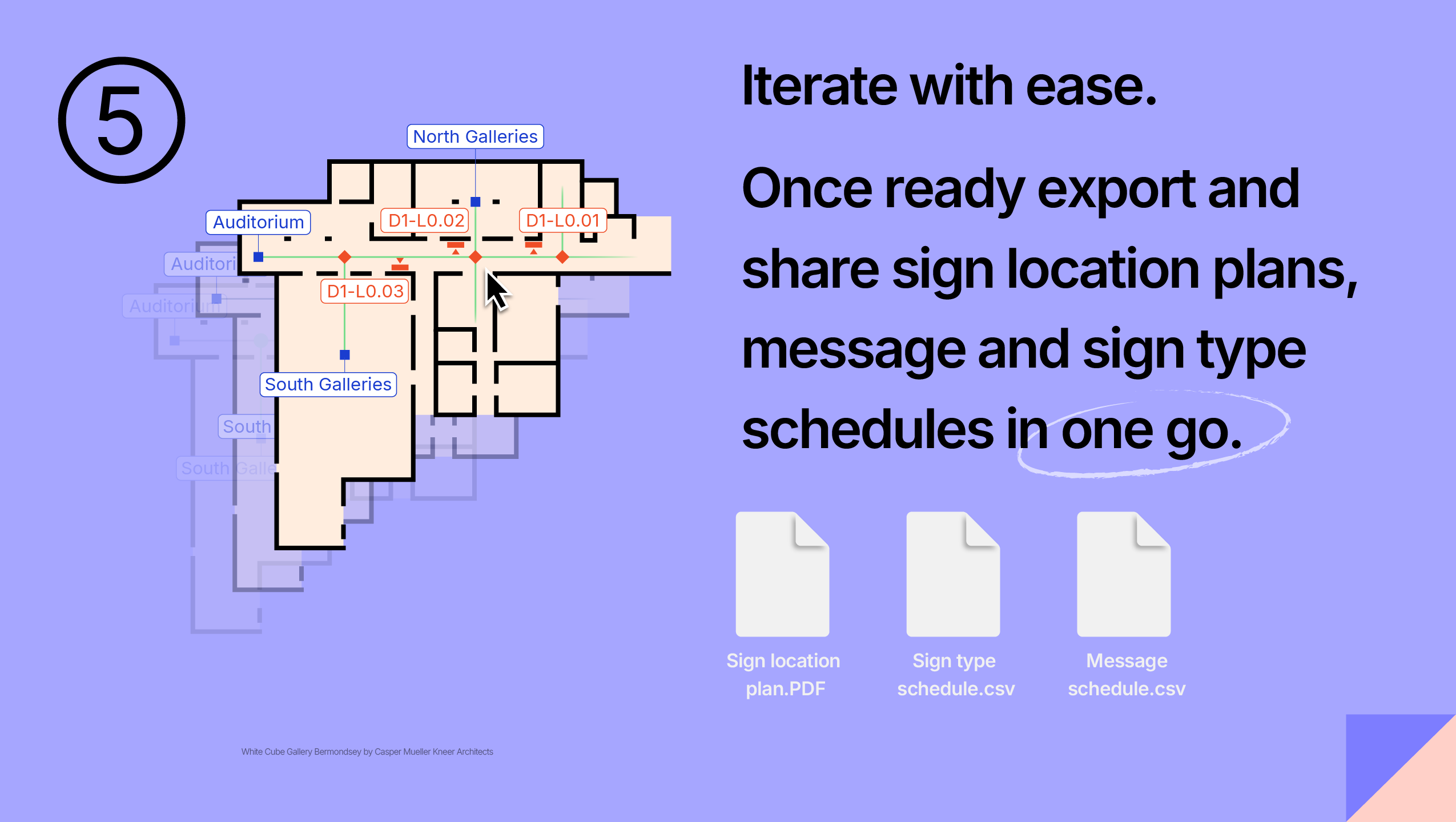
Insights and Updates

Wayfinding Planner v1.5. Units, colours and control
Work in the units your project needs, prepare reports for your recipients, and refine sign colours, codes and numbering. WFP v1.5 gives you more control from setup to handover.

Wayfinding Planner v1.4: more control over message presentation
Wayfinding Planner v1.4 brings more control over message presentation, from project-wide automatic sorting settings to per-face manual ordering , and adds new native self-update support for macOS and Windows installations.

Wayfinding Planner v1.3: smarter message generation and more
Wayfinding Planner v1.3 introduces a smart Message Generation Layer backed by a new project-wide Destination Dictionary. Together with new visual inspection tools, it helps create better wayfinding strategies through progressive disclosure, intelligent aggregation, and sign-capacity-aware message selection.

Wayfinding Planner v1.2: meet the multi-sided signs
Wayfinding Planner v1.2 introduces custom multi-sided signs, improved selection tools, drag-and-drop project opening, flexible reports, and on-demand sign renumbering
Frequently Asked Questions
What outputs does Wayfinding Planner produce?
Wayfinding Planner exports a complete deliverables package in one click: sign location plans as PDF and/or SVG, plus the message schedule and the sign schedule / bill of quantities (BoQ) as CSV — ready to hand to designers, fabricators, and clients.
What is a sign location plan?
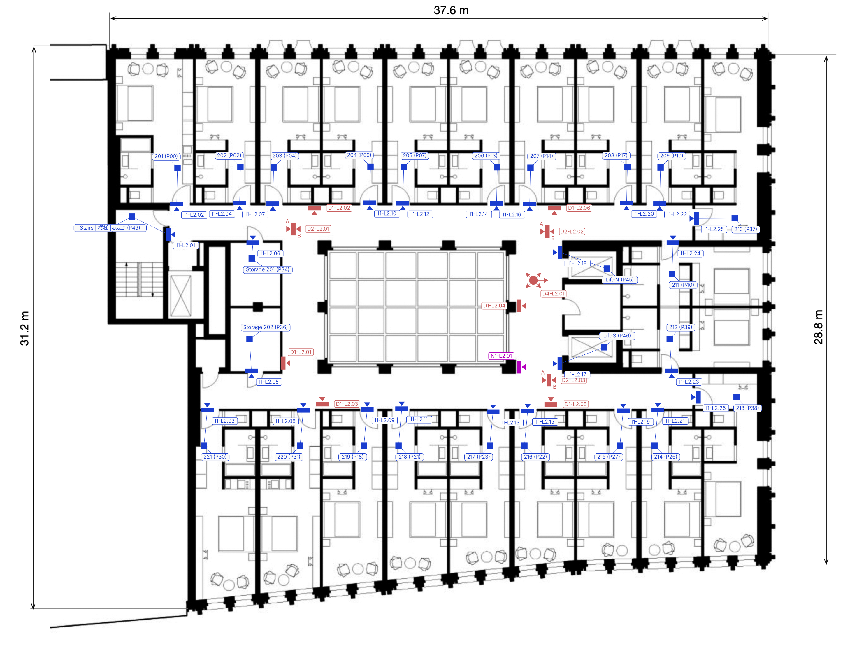
A sign location plan is a PDF or SVG drawing showing every sign's position, orientation, and unique ID over a level drawing — a floor plan, urban plan, or landscape map. Optional path network elements, such as target points, can be included at export.
Sign Location Plan example:
What is a sign schedule (sign BoQ)?
A sign schedule — also called a sign bill of quantities (BoQ) — is a spreadsheet counting the sign instances of each sign type, together with the type's properties: description, fixing mode, dimensions, and more. Wayfinding Planner exports it as CSV, ready for estimation or analysis.
Example of a sign BoQ.

What is a message schedule?
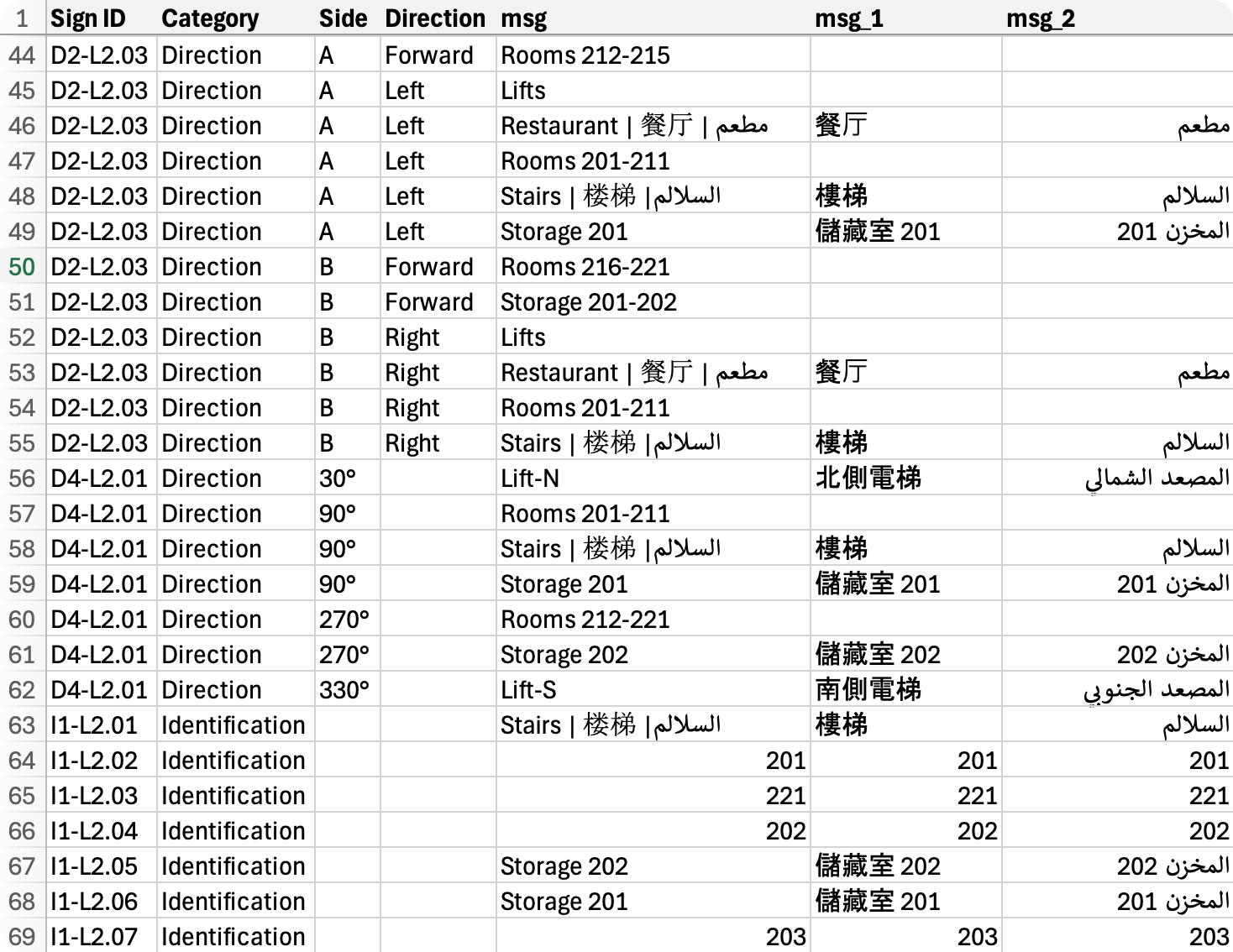
A message schedule is a spreadsheet that defines exactly what each sign says.
It lists every message on every sign face, together with the sign ID, sign category and type, walking direction where applicable, and the optional Message 1 and Message 2 fields from the Destination Dictionary. Wayfinding Planner generates it automatically from your wayfinding model and exports it as CSV.
Example of a message schedule.
What do I need to run Wayfinding Planner?
Wayfinding Planner runs on macOS, Windows, and web with an active trial or subscription. You'll need:
- macOS 14+ (Apple Silicon or Intel) or a 64-bit Windows 11 PC, or a recent Chrome, Firefox, or Safari browser for the web version.
- an Apple M1 / Intel i9 processor or better; 16 GB RAM; 120 MB of disk space; discrete GPU recommended.
- native apps need an internet connection for activation and periodic license checks.
- web version is always online.
Is Wayfinding Planner a graphic design application?
No — Wayfinding Planner covers the strategy creation stage of a signage project: sign locations, messages, and schedules. Graphic design of the signs themselves happens in dedicated tools such as Adobe Illustrator. There is no direct integration, but the exported PDF/SVG plans and CSV schedules are made to drive that downstream design and fabrication work.
Is Wayfinding Planner an AI-driven solution?
No. Wayfinding Planner uses deterministic, rule-based automation — routes and messages are computed from your wayfinding model: path network, destination weights, progressive disclosure parameters, and other model settings, so results are repeatable and auditable. Every design decision stays with you and your expertise.
Is Wayfinding Planner a cloud-based solution?
No. Your entire project — the model and all design metadata — lives in a single portable .wfp file you can open and save on macOS, Windows, and the web. Your data stays in your own storage, not locked into a cloud account.
Do you offer a free trial?
Yes — every plan includes a 14-day free trial, no credit card required. Go to the pricing page and click Start 14-day trial under the plan you want.